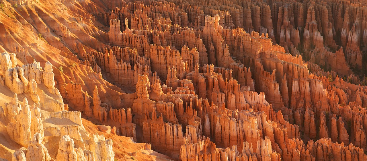
Bryce Canyon National Park, situated in southern Utah, is an amphitheater of geological wonder. Unlike any other, it is known for its hoodoos—towering, spire-shaped rock formations created by frost weathering and stream erosion. The park's landscape is a kaleidoscope of color, with red, orange, and white hues dominating the panoramic vistas.
Spanning across high plateau country, Bryce Canyon offers a unique series of natural amphitheaters and bowls, carved into the edge of a high plateau. The park's altitude varies dramatically, providing diverse environments from dense forests to sprawling meadows, home to a wide range of flora and fauna.
With its dazzling array of natural sculptures, serene pine forests, and clear, dark skies perfect for stargazing, Bryce Canyon National Park invites visitors to immerse themselves in its otherworldly beauty and tranquility.
Biome at Bryce Canyon National Park
Bryce Canyon National Park, located in Utah, is a unique and diverse ecosystem that spans multiple biomes. The park's vast territory encompasses a range of elevations, from 6,300 to 9,000 feet (1,920 to 2,743 meters) above sea level, which supports a variety of biomes. Keep on reading to learn more about the biomes at Bryce Canyon National Park
Airports Near Bryce Canyon National Park
This is a list of the closest airports to the park, if you plan on flying into Bryce Canyon click here to read our recommendations.
| Distance to Park | Drive Time | ||
| Bryce Canyon Airport | 6.7 miles | 7 mins | Get Directions |
| Kanab Municipal Airport | 127.7 miles | 1 hour 28 mins | Get Directions |
| Cedar City Regional Airport | 148.1 miles | 1 hour 34 mins | Get Directions |
| Richfield Municipal Airport | 158.6 miles | 1 hour 41 mins | Get Directions |
| Fillmore Municipal Airport | 199.3 miles | 1 hour 59 mins | Get Directions |
| Milford Municipal/Ben And Judy Briscoe Field | 199.3 miles | 2 hours 30 mins | Get Directions |
| Bullfrog Basin Airport | 227.3 miles | 4 hours 8 mins | Get Directions |
| Page Municipal Airport | 243.1 miles | 2 hours 38 mins | Get Directions |
| Hanksville Airport | 249.1 miles | 2 hours 56 mins | Get Directions |
| St George Regional Airport | 249.3 miles | 2 hours 25 mins | Get Directions |
Cities Near Bryce Canyon National Park
Here are some of the closest cities and towns near the park, take a look at our recommendations for where to stay when visiting Bryce Canyon.

| Distance to Park | ||
| Panguitch | 36.0 miles | Get Directions |
| Parowan | 64.5 miles | Get Directions |
| Kanab | 65.7 miles | Get Directions |
| Cedar City | 78.6 miles | Get Directions |
| Beaver | 88.3 miles | Get Directions |
| Page | 97.0 miles | Get Directions |
| Loa | 103.9 miles | Get Directions |
| Hurricane | 107.5 miles | Get Directions |
| Washington | 127.2 miles | Get Directions |
| Richfield | 134.0 miles | Get Directions |
Bryce Canyon National Park TimeZone
The timezone at Bryce Canyon is America/Denver, the current time here is:
Sunrise and Sunset Times at Bryce Canyon National Park
This table shows the sunrise and sunset times at Bryce Canyon for the next 10 days, use it to plan your day around Bryce Canyon stunning displays.
|
Date |
Sunrise |
Sunset |
| January 16, 2026 | 07:40 | 17:36 |
| January 17, 2026 | 07:40 | 17:37 |
| January 18, 2026 | 07:39 | 17:38 |
| January 19, 2026 | 07:39 | 17:39 |
| January 20, 2026 | 07:38 | 17:40 |
| January 21, 2026 | 07:38 | 17:42 |
| January 22, 2026 | 07:37 | 17:43 |
| January 23, 2026 | 07:37 | 17:44 |
| January 24, 2026 | 07:36 | 17:45 |
| January 25, 2026 | 07:35 | 17:46 |
Weather at Bryce Canyon National Park
This table shows weather averages around the year at Bryce Canyon National Park, it provides information on average rainfall, as well as maximum and minimum temperatures. Be sure to consult it when planning your trip.
|
Month |
Temperatures |
Precipitation |
Our Opinion |
|---|---|---|---|
|
Month |
Temperatures |
Precipitation |
Our Opinion |
|
Month |
Temperatures |
Precipitation |
Our Opinion |
|
Month |
Temperatures |
Precipitation |
Our Opinion |
|
Month |
Temperatures |
Precipitation |
Our Opinion |
|
Month |
Temperatures |
Precipitation |
Our Opinion |
|
Month |
Temperatures |
Precipitation |
Our Opinion |
|
Month |
Temperatures |
Precipitation |
Our Opinion |
|
Month |
Temperatures |
Precipitation |
Our Opinion |
|
Month |
Temperatures |
Precipitation |
Our Opinion |
|
Month |
Temperatures |
Precipitation |
Our Opinion |
| January | -14.1 °C / 0.9 °C | 9.1mm | Bad Weather |
| February | -11.6 °C / 3.2 °C | 7.0mm | Bad Weather |
| April | -4.0 °C / 12.1 °C | 3.8mm | Bad Weather |
| May | 0.0 °C / 17.7 °C | 3.2mm | Bad Weather |
| June | 3.4 °C / 20.6 °C | 3.2mm | Good Weather |
| July | 9.0 °C / 27.3 °C | 13.4mm | Perfect Weather |
| August | 7.7 °C / 25.4 °C | 16.6mm | Perfect Weather |
| September | 3.9 °C / 22.0 °C | 11.7mm | Good Weather |
| October | -2.5 °C / 14.3 °C | 6.7mm | Bad Weather |
| November | -8.8 °C / 7.9 °C | 3.6mm | Bad Weather |
| December | -13.7 °C / 1.8 °C | 25.3mm | Bad Weather |
